Integrated Land Information Management System for Modern Land Governance
05-Feb-2026Managing land assets today is no longer just about records — it’s about visibility, compliance, accuracy, and control. Our Integrated Land Information Management System (LAMS) is a powerful, GIS-enabled Land Management System designed to digitize, centralize, and streamline the complete lifecycle of land acquisition, land records management, allotment, and monitoring — all through a single, unified platform.
Built for enterprises, PSUs, and government organizations, LAMS transforms fragmented land records, revenue records, legal data, and spatial information into a secure, searchable, and actionable digital ecosystem.
One Platform for Complete Land Records & Management
LAMS functions as a next-generation Integrated Land Records Management System, bringing together textual records, spatial maps, ownership details, legal documents, and financial data under one digital roof.
With real-time access to online land records, organizations can eliminate data silos, reduce disputes, and improve transparency across departments and locations.
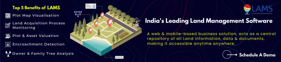
What You Can Manage Seamlessly:
- 1. Digital land records & documents
- 2. Land acquisition & allotment stages
- 3. Ownership, co-ownership & family tree data
- 4. Revenue records & land revenue system details
- 5. Legal cases, disputes & encumbrances
- 6. Compensation, resettlement & payments
- 7. GIS maps, satellite imagery & encroachment detection
Advanced Land Records Management Information System
As a comprehensive Land Records Management Information System, LAMS enables accurate recording, tracking, and retrieval of land information across thousands of plots and stakeholders.
Key Capabilities:
Land Record Search by Name
Quickly locate land ownership details, family trees, and associated plots using owner or stakeholder information.
Digital Land Record Creation & Maintenance
Convert legacy records into secure, structured digital land records with version control and audit trails.
Revenue Record & Land Revenue System Integration
Maintain up-to-date revenue records, tax calculations, duties, and compensation data aligned with statutory requirements.
Centralized Land Information Repository
Store and manage deeds, approvals, court orders, surveys, and historical documents against each plot.
GIS-Enabled Integrated Land Management System
Unlike conventional land record software, LAMS is a location-driven Land Management Information System powered by GIS and satellite imagery.
Location Analytics That Drive Decisions:
- 1. Plot-wise GIS map visualization with administrative boundaries
- 2. Thematic maps based on land type, status, and acquisition stage
- 3. Integration of satellite images (Google/Bing) as base layers
- 4. Encroachment and change detection using satellite data
- 5. Digitized resettlement colony maps with real-time PAF status
This spatial intelligence makes LAMS a true Land Records Management & Information System, bridging the gap between records and reality on the ground.
End-to-End Land Acquisition & Allotment Monitoring
LAMS supports the complete land acquisition process in line with state-wise LARR Acts, making it ideal for large-scale projects and multi-location land portfolios.
Acquisition & Allotment Features:
- 1. Stage-wise tracking using Gantt charts & timelines
- 2. Monitoring of approvals, hearings, and renewals
- 3. Owner & family tree analysis for accurate compensation
- 4. Plot & asset valuation with automated tax and duty calculation
- 5. ERP-ready payment modules for compensation & rehabilitation
Legal, Dispute & Encroachment Management
Land-related risks often arise from disputes, unclear ownership, or encroachments. LAMS addresses these challenges proactively.
- 1. Court case & advocate management
- 2. Tracking of encumbrances and legal notices
- 3. Alerts for upcoming hearings and compliance deadlines
- 4. GIS-based encroachment detection using satellite imagery
This makes LAMS a robust Land Record Management & Information System that safeguards both assets and compliance.
Mobile-Ready, Offline-Capable Land Information System
Field operations don’t always have connectivity. LAMS includes Android & iOS mobile apps for real-time and offline data capture.
- 1. Offline surveys and inspections
- 2. Geo-tagged photos and field verification
- 3. Sync data once connectivity is restored
- 4. Accurate ground-level updates to the central land information system
Built for Scale: From State Projects to Enterprise Land Banks
Whether you’re managing industrial land, mining leases, infrastructure corridors, or government land banks, LAMS adapts to your needs.
- 1. Ideal for integrated land records management system Assam–style implementations
- 2. Supports multi-unit, multi-location land portfolios
- 3. Fully customizable dashboards and reports
- 4. Secure role-based access for departments and stakeholders
Why Organizations Choose Our Land Management System
- 1. True Integrated Land Information Management System
- 2. GIS + records + legal + financial data in one platform
- 3. Improved transparency, auditability & governance
- 4. Faster access to online land records & land information
- 5. Reduced disputes, delays, and compliance risks
- 6. Scalable for enterprise and government use
Trusted by leading industrial groups and public organizations, LAMS sets the benchmark for modern digital land governance.
Transform Your Land Records Into Strategic Assets
Move beyond static registers and fragmented spreadsheets. Adopt a future-ready Integrated Land Management System that delivers clarity, control, and confidence across your land portfolio.
Frequently Asked Questions (FAQs)
1. What is an Integrated Land Information Management System?
An Integrated Land Information Management System is a digital platform that centralizes land records, ownership details, GIS maps, legal documents, and revenue data into a single system. It helps organizations manage land acquisition, allotment, monitoring, and compliance with complete transparency and accuracy.
2. How is LAMS different from a traditional land records management system?
Unlike traditional land records management systems that store only textual records, LAMS combines digital land records, GIS mapping, satellite imagery, legal tracking, and financial workflows. This makes it a fully integrated land management system rather than just a document repository.
3. Can LAMS be used as a land records management information system for government projects?
Yes. LAMS is designed for large-scale government and PSU projects and works as a comprehensive land records management information system. It supports state-wise land acquisition laws, revenue records, resettlement tracking, and audit-ready reporting.
4. Does the system support digital and online land records?
Yes. LAMS enables the creation and management of digital land records and provides secure access to online land records, allowing authorized users to retrieve land information anytime from a centralized platform.
5. Is it possible to search land records by owner name?
Yes. LAMS includes a land record search by name feature that allows users to quickly locate plots, ownership details, family tree information, and associated land documents.
6. How does LAMS handle revenue records and land revenue data?
LAMS maintains detailed revenue records and integrates land revenue system data such as taxes, duties, compensation, and payments. Automated calculations reduce errors and improve financial transparency.
7. Can LAMS monitor land acquisition and allotment stages?
Absolutely. The system tracks land acquisition and allotment stages using timelines and Gantt charts, aligned with state-specific land acquisition acts. It also provides alerts for approvals, renewals, and pending actions.
8. Does the land management system include GIS and mapping features?
Yes. LAMS is a GIS-enabled land management information system that offers plot-wise map visualization, thematic maps, satellite imagery integration, and real-time location analytics.
9. How does LAMS help in encroachment detection?
LAMS uses satellite imagery and GIS-based change detection to identify potential encroachments. This allows organizations to take proactive action and protect land assets effectively.
10. Can LAMS manage legal cases and disputes related to land?
Yes. The platform includes modules for court case management, advocate tracking, dispute monitoring, and encumbrance recording, making it a complete land records management & information system.
11. Is LAMS suitable for multi-location and enterprise land portfolios?
Yes. LAMS is built to manage multi-location land assets across units, districts, and states, making it ideal for enterprises, infrastructure projects, and industrial land banks.
12. Does the system support mobile and offline data collection?
Yes. LAMS offers Android and iOS mobile applications with offline data capture, enabling field teams to collect land survey data even in areas without network connectivity.
13. Can LAMS be customized for state-specific land record systems like Assam?
Yes. LAMS is fully configurable and can be customized as an integrated land records management system for Assam or other states, based on local land laws, processes, and reporting requirements.
14. Who should use an integrated land management system like LAMS?
LAMS is ideal for government departments, PSUs, infrastructure companies, mining and steel industries, and any organization managing large or complex land portfolios.
15. How does LAMS improve transparency and compliance?
By centralizing land information, digitizing records, enabling real-time tracking, and maintaining audit trails, LAMS improves transparency, reduces disputes, and ensures regulatory compliance across land operations.
ABOUT THE AUTHOR

RELATED ARTICLES

Digital land management in South Africa with LAMS: ..

Explore how digital land management systems like L ..

Explore how GIS-based land management systems and ..